Test Excavations at the Court House: Archaeological Report Block 19 Building 3
Colonial Williamsburg Foundation Library Research Report Series - 0168
Colonial Williamsburg Foundation Library
Williamsburg, Virginia
1990
Test Excavations at the Court House:
Archaeological Report
Office of Archaeological Excavation
Department of Archaeology
Colonial Williamsburg Foundation
Williamsburg, Virginia
1986
Abstract
At the request of the Department of Architectural Research, archaeological excavations were conducted at the Court House on Block 19 between June 2-9, 1986. The purpose of these excavations was to locate, if present, the original placement and configuration of a chimney base in the west ancillary wing of the building. Evidence of structural support for a partition wall dividing the west wing into two rooms was also sought. This work was conducted by Gregory Brown and Patricia Samford of the Colonial Williamsburg Foundation's Office of Archaeological Excavation.
Excavations along the chimney base revealed that all original brickwork had been destroyed by the reconstruction of the Court House after the 1911 fire, with only a portion of the original builder's trench for the hearth located adjacent to its base. A test unit placed against the west wall of the building, spanning the area where a partition wall was expected, showed no evidence of structural support for such a wall. Soil strata in the areas tested indicated a natural accumulation of soil through time, with no indication of previous structural activity on the site of the Court House.
Acknowledgments
As with any project, large or small, a number of persons contributed their efforts to make this work go smoothly. Gregory Brown assisted in the excavation and in editing this report. Virginia L. Caldwell prepared the graphics, while Tamera Mams is responsible for the photographic prints in the report. Advice and support were provided, by Carl Lounsbury and William Graham of the Architectural Research Department.
Introduction
This archaeological work was conducted as part of an ongoing project whose goal is to reinterpret the Court House to its 18th century appearance and function. The purpose of the excavation was to determine if any traces remained of original (1770) architectural features that would aid in this interpretation.
After the fire of 1911, the entire Court House, with the exception of the foundation walls which had been left standing, was rebuilt. Although a boiler room was installed under the eastern portion of the building, the remainder of the crawlspace under the Court House was apparently not disturbed during this reconstruction. The two interior chimneys were rebuilt at this time, but the extent of this work was not documented.
After the Colonial Williamsburg Foundation purchased the Court House in the early 1930s, a complete renovation was planned, in order to restore the interior and exterior of the building to its 18th century appearance. This work necessitated numerous tasks, including removal of the roof, electrical work, plumbing, and window framing, while carefully preserving the original brickwork.
The architectural report prepared on the Court House indicates that the chimneys were replacements of the originals, that had been "rebuilt to the size, height, and detail of the original chimneys" (Kocher & Dearstyne 1950:19). Reference is also made to "building new ... foundation walls on top of existing footings where required" (Perry, Shaw & Hepburn 1931:3). From this statement, it was not known whether any of the original hearth foundations still existed below grade, and if so, whether 4 the reconstructed hearth was built in the exact configuration of the original.
Information was also desired on whether the hearth had also originally opened into the northern room of the west wing. If this had been the case, remnants of the original brickwork should have been evident on the north side of the hearth base, reaching beyond the extent of the current hearth, which is reconstructed as opening only into the southern room. Units A and B were placed against the southeast and north walls of the hearth in order to determine if any traces remained of the original construction (Figure 1).
A third excavation unit (C) was placed against the western foundation wall of the building in order to determine whether remnants of structural support for a partition wall dividing the west wing into two rooms existed in the crawlspace. This support could take the form of a continuous brick foundation spanning the width of the wing, or as brick or wooden piers.
5
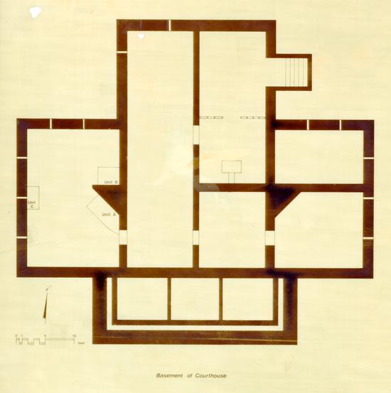 Figure 1. Location of excavation units at the Court House.
Brief History of the Courthouse
There is no evidence that any structures were located on the northern half of the Market Square prior to the construction of the Court House (Kendrew 1939). An act of the General Assembly set aside Market Square as a market area in the early 18th century. Here produce and livestock was sold, slaves auctioned, biannual fairs held, and the militia. Maps prepared by the French military during the Revolutionary War period show only the Court House standing on Market Square north of Duke of Gloucester Street (Frenchman's 1781, Berthier 1781, Desandrouins 1781).
On March 23, 1769, the Virginia Gazette carried notice of a decision to build "a commodious Brick Court-House" and advertising for a builder.l Although originally the Court House was to contain only the Williamsburg Hustings court, the cost for building the structure was found to be prohibitive. The aid of James City County was thus sought for financing, resulting in the construction of a courthouse which would serve the needs of both the city and the county. Further problems arose, however, when it was discovered that the Market Square location planned for the Court House was just north of the James City County boundary, in York County. To solve this problem, a petition was passed on May 22, 1770, which annexed a small plot of land on which the Court House now stands to James City County (Journal of the House of Burgesses 1770, p. 95). It is believed that construction of the Court House began around this time. After the Court House was completed later that year, it became the location of the regular sessions of the James City County Court and the Hustings Court.
According to Benjamin Waller, the Court House served as barracks for soldiers during the Revolutionary War (Calendar of 7 Virginia State Papers, II, p. 666). The building was again called into an active military role at the time of the Battle of Williamsburg on May 5, 1862, when it was used as a temporary hospital for both Federal and Confederate wounded. The building later sustained damages at the hands of the Federal troops during the subsequent three-year occupation of Williamsburg. As a result of this damage, court was held in the basement of the Baptist Church across the street on Block 12 (Charles 1928). Shortly after the end of the war, the building resumed duty as a Court House (Trudell 1932), in which capacity it functioned until the early 1930s.
On the night of April 6, 1911, for reasons unknown, the Court House caught fire. Although the original foundation walls were left standing, the building interior was gutted. Most of the records managed to be saved, but virtually everything else inside the building was lost. The building was reconstructed later that year, using the original walls as the basis of the work.
In December 1931, the City of Williamsburg and James City County conveyed the Court House and surrounding green to the Colonial Williamsburg Foundation. Restoration of the Court House by the Foundation under the direction of Perry, Shaw, and Hepburn, Architects, was undertaken between April and October 1932, with the building opened to the public in April of 1933 (Goodwin 1959:329). Up until 1973, the building served as a museum exhibiting artifacts recovered from archaeological excavations in Colonial Williamsburg. Currently the Court House is used by the Colonial Williamsburg Foundation as a visitor information and ticket center.
Previous Archaeological Excavations
Although several small projects have been completed around and underneath the Court House, no large scale excavations of this area or the north side of Market Square have ever occurred. The cross-trenching common to the early years of the Restoration was not undertaken, perhaps because no buildings other than the Court House are documented as having stood on the that side of the green. Each of the Court House archaeological projects will be discussed briefly below.
In 1932, archaeological excavations were conducted on the south side of the Court House, in an effort to locate information about the original front steps. It is documented that the stone steps for the Court House were imported from England during 1772 (Goodwin 1954:7; Tyler 1907:xiii), but over the years these must have been removed. During the 1932 restoration, Colonial Williamsburg ordered stone to replace the Court House steps (Archives 1932).
No report has been located for the 1932 archaeological work, but several photographs (N2636-N2638) and a detailed map exist, and it is possible to draw some conclusions about the excavation from these. The photographs and the Archaeological and Research Key Map (1932) show an opened rectangular area around the front steps (Block 19, Area C) approximately 55' EW x 18' NS. Uncovered there were remnants of brick described as "colonial brickwork" (Knight 1932). These appear to have been used as seating for the stone steps or perhaps as entrance steps prior to the arrival of the imported stone steps in 1772 (Figure 2).
9
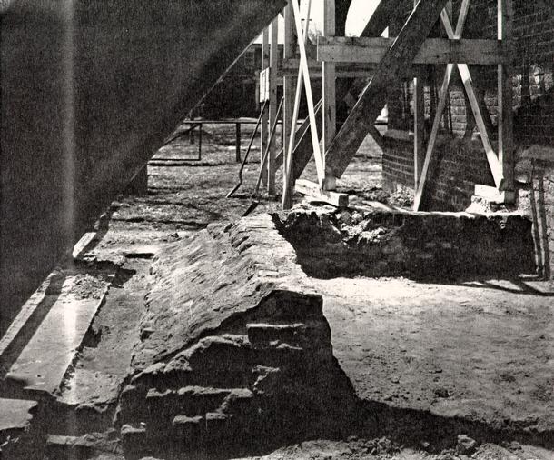 Figure 2. 1932 Excavation of Entrance Steps.
Brief excavations were conducted around the interior foundation walls of the Court House in November of 1959 by Ivor Noel Hume and his staff (Noel Hume 1959). This work, which was not discussed in detail, revealed only a scattering of debris from a fire, probably that which occurred in 1911.
Additional archaeological excavation took place at the Court House during late 1973 and early 1974, again under the direction of Ivor Noel Hume. Results of this work are described in the "Monthly Reports on Archaeological Activities" for January of 1974. The purpose of this excavation, done at the request of Paul Buchanan of the Department of Architecture, was to determine the existence of a holding cell for prisoners in the basement, as well as a stairway leading up from it to the courtroom above. Excavation conducted in the crawlspace under the northern dais (Figure 3) did not indicate the presence of a basement holding cell during any period of the Court House's history.
The 1974 excavation did, however, reveal evidence of strata associated with the 1932 restoration of the Court House by the Colonial Williamsburg Foundation, as well as features relating to the earlier reconstruction after the 1911 fire. A layer of grey loam and brick rubble was interpreted as being connected with remodeling done between 1835-1840 or repairs made after the Civil War. Testing beneath the grey loam and rubble stratum revealed a layer of gray loam that was virtually devoid of artifacts. This was interpreted as a slightly disturbed natural humus.
Information available from the 1932 excavation was limited due to the absence of a report describing the purpose and results of the work. Although no basement holding cell was revealed through the excavation under the northern dais, it is possible that such a feature did at one time exist in a different area. It could have, for example, been located under the eastern wing, 11 where a boiler room was constructed after the 1911 fire, for example.
12
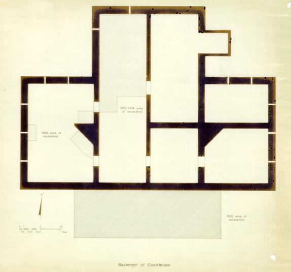 Figure 3. Locations of previous excavations at the Court House.
Field Methods
During the 1986 excavation, three test units of varying sizes were placed under the western wing of the Court House in an effort to answer the questions posed by the Architectural Research Department. No grid was established due to the difficulty of accomplishing such in the crawlspace; rather the units were located with respect to the foundation walls of the Court House (Figure 1).
All excavation was done using trowels, with the soil removed in stratigraphic layers on the basis of color and texture changes. None of the soil was screened, but it was felt that careful hand excavation obviated the need for screening to recover small finds. Features, when they were encountered, were mapped in plan, bisected, and then mapped in profile before being completely removed.
Using the current recording system employed by the OAE, information on soil conditions, inclusions, and stratigraphic relationships was recorded on context forms. An example of a completed context record is shown in Appendix 1. Each context consisted of a unique layer or feature in a given test unit, with the same layers or features within separate test units given different context numbers.
Soil samples were taken from each soil layer for color and texture analysis in the laboratory. Color was determined using Munsell Color Charts (1975), while texture was analyzed by determining the relative proportion of soil particle sizes in the sample (Hunter 1983). Samples of brick were saved from those layers which contained them. The presence of charcoal, ash, brick flecking, and oyster shell was noted, but samples of these materials were not saved. All other cultural material, such as 14 ceramics, bone, metals and glass, were retained for processing and analysis and are listed in Appendix 2.
Laboratory Methods
Artifacts generated during the brief Court House excavation were received for treatment at the office of Archaeological Excavation laboratory. Each group of artifacts, separated according to context, was washed and then sorted into general types. Ceramics, pipestems, identifiable bone, and datable glass were labeled with context information using India ink. The remainder of the artifacts, such as iron nails, other scraps of metal, unidentifiable bone, and window glass were not numbered separately, but placed in bags which contained tags displaying their context numbers. All artifacts were identified and inventoried (Appendix 2) and a terminus post quem date assigned on the basis of the artifact in each group with the latest documented date of manufacture. (The principle of terminus post quem is discussed in detail in Noel Hume 1975:69). Some materials which were deemed to have no research value after their presence had been recorded, such as slate and brick fragments, were de-accessioned. Due to the small scope of the project and the minimal amount of artifacts recovered, typical laboratory procedures, such as cross-mending and minimum vessel counts of glass and ceramics, were not undertaken. After analysis, the artifacts were bagged and boxed according to their context, and stored in the warehouse facilities at the Office of Archaeological Excavation.
Results
The excavation under the west wing revealed four basic layers of soil, consistent across each of the three test units. These strata consisted of debris from the 1911 and/or 1932 reconstruction, and soil layers that appear to be associated with the property during the 18th century. Figure 4 represents the stratigraphy as recorded in Unit A. Several features, mainly in the form of 20th-century utility trenches and builder's trenches were also located. The results of the testing will be discussed below.
Reconstruction Debris
The uppermost layer revealed in the courthouse excavation was debris related to either the 1911 reconstruction or the 1932 restoration of the courthouse (19-1, -8, -16). This layer consisted of a white friable sand mixed with brick bats, concrete, asbestos, tar paper, and cement mortar, extending from .1 to .3' below the present ground level in the crawlspace. Artifacts recovered from this layer included melted window glass and wire nails.
Brown Silty Sand
The reconstruction debris sealed a layer of brown silty sand
(19-4, -12, -20). This layer, containing sparse fleckings of
shell and charcoal, ranged from .1' thick at the southwest edge
of Unit A, to .35' thick at the northwest end of the same unit.
It continued to increase in thickness to the north in Unit B,
reaching a maximum thickness of .4'. Artifacts included
fragments of tin enamelled earthenware, white salt glazed
16
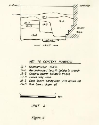 Figure 4. Stratigraphy recorded in Unit A.
17
stoneware, wine bottle glass, nails, and window glass. A
terminus post quem of 1720 for the deposition of the strata was
provided by a fragment of white salt glazed stoneware (Pittman
1983).
Figure 4. Stratigraphy recorded in Unit A.
17
stoneware, wine bottle glass, nails, and window glass. A
terminus post quem of 1720 for the deposition of the strata was
provided by a fragment of white salt glazed stoneware (Pittman
1983).
Dark Brown Sandy Loam with Brown Silt
A layer of dark brown loam with mottlings of brown silt (19- 5, -13, -21) was apparent in all three test units, sealed below the brown silty sand. Bits of broken oyster shell, charcoal and brick were present in this layer, as well as wine bottle and window glass, white clay pipestems, clothing items and several small fragments of ceramics. The ceramic type of most recent manufacture in the layer was white salt glazed stoneware, providing a date of post-1720 for the deposit (Pittman 1983).
Dark Brown Clayey Silt
Beneath the dark brown sandy loam was a layer of dark brown clayey silt (19-6, -14, -23). This layer was consistently .7' in thickness across all three test units, and contained sparse inclusions of charcoal, brick, and shell mortar. A terminus post quem of 1715 for the deposition of the layer was provided by a fragment of white slipped salt glazed stoneware, recovered from Unit C (Pittman 1983).
Reconstructed Hearth Builder's Trench
In an effort to locate any original structural remains of
the west wing corner hearth, two test units (A and B) were
located adjacent to the foundation of the reconstructed hearth.
A builder's trench associated with the 1911 renovation of the
Court House extended 1.2 - 1.3' out from the reconstructed hearth
foundation (Figures 4 & 5). This builder's trench (19-2, -10) was filled with a dark greyish brown sandy loam, and contained
18
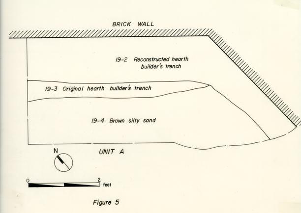 Figure 5. Plan of Builder's Trenches in Unit A.
19
fragments of slate, leaded window glass, and brick bits. No
terminus post quem was assignable on the basis of the artifacts
from the builder's trench, but examination of the mortar and
brickwork of the stepped hearth base indicated that it had been
reconstructed and was not 18th century in origin. The builder's
trench was sealed by the layer of 191 1/32 reconstruction debris.
At the bottom of the builder's trench in Unit B was a lense of
dark brown sandy loam, approximately .1' thick. This lense
contained a fragment of a blue and white hand-painted Chinese
porcelain bowl, and probably represents soil from Layer 19-12 or
19-13, which was accidentally scattered in the trench during the
reconstruction of the hearth.
Figure 5. Plan of Builder's Trenches in Unit A.
19
fragments of slate, leaded window glass, and brick bits. No
terminus post quem was assignable on the basis of the artifacts
from the builder's trench, but examination of the mortar and
brickwork of the stepped hearth base indicated that it had been
reconstructed and was not 18th century in origin. The builder's
trench was sealed by the layer of 191 1/32 reconstruction debris.
At the bottom of the builder's trench in Unit B was a lense of
dark brown sandy loam, approximately .1' thick. This lense
contained a fragment of a blue and white hand-painted Chinese
porcelain bowl, and probably represents soil from Layer 19-12 or
19-13, which was accidentally scattered in the trench during the
reconstruction of the hearth.
Original Hearth Builder's Trench
A feature interpreted as the builder's trench for the original 1770 hearth was evident in Unit A (19-3). This feature extended from the hearth wall a distance of 1.6', and was cut by the 1911 builder's trench (See Figures 4 & 5). It was filled with a dark greyish brown sandy loam and contained some brick rubble and mortar. There were no artifacts recovered from this feature, which cut the layer of brown silty sand. This builder's trench, which extended the entire length of Unit A, was not apparent in Unit B, to the north. It is evident that the reconstructed builder's trench extends to a greater depth than the original, thus negating the survival chances for any of the lower original brickwork.
West Wall Builder's Trench
A builder's trench for the interior of the west wall of the Court House was excavated in Unit C (19-22). This narrow trench extended 2' from the foundation wall and was filled with a dark brown sandy loam (Figure 6). The trench, reaching to the bottom of the stepped foundation base, contained no artifacts.
20
 Figure 6. Profile of stratigraphy in Unit C.
Modern Utility Trenches
Three trenches for the installation of utility pipes were excavated during the testing at the Court House. An east-west running trench was located at the northern extent of Unit B, and contained a 1" diameter iron pipe (19-11). Two other pipe trenches were located in Unit C, running north-south. The fill of one trench was indistinguishable from the reconstruction debris layer, and was thus removed with context 19-16. The second trench, containing a 4" diameter iron pipe, was removed as 19-19. The installation of this utility line postdated the 1911 fire, since melted window glass was included in its fill.
Conclusion
As excavation proceeded underneath the crawlspace at the Court House, it became apparent that archaeology was not going to be able to provide all of the information desired by the Architectural Research Department. Past restoration of the building seemed to have destroyed all of the original brickwork for the chimney, making the exact configuration of the hearth impossible to determine. Also, no evidence came to light regarding a partition wall between the north and south rooms of the west wing. Several conclusions, however, can be drawn using results from the excavation.
It appears that the hearth in the west wing opened originally only into the southern room, while the original builder's trench for the hearth had not been completely obliterated by the 1911 reconstruction efforts in Unit A, Unit B showed no signs of an original builder's trench. If another hearth had opened into the northern room of the west wing, remnants of brick from the original hearth base and a builder's trench associated with it would have been expected extending northwest of the foundation as it is constructed today. None of this was evident in Unit B, leading to the conclusion that the hearth had originally opened only into one room in the west wing, leaving the northern room unheated.
Unit C was placed against the interior of the western wall of the Court House in order to search for structural remnants of a partition wall dividing the west wing into two rooms. This evidence could have taken the form of a continuous brick foundation stretching the width of the wing, or perhaps as brick or wooden piers for supporting the partition wall. It was also 23 possible that no support was needed for spanning that the width of the west wing, and that no such evidence would be found. Although the unit spanned across that area where a partition wall was expected, no traces of a wall or piers were apparent. Two pipe trenches of recent origin cut Unit C, running north-south, but intact stratigraphic sequences were visible on either side of these utilities. Therefore, if any evidence did exist in the form of a brick wall, it would have been visible in this area. There is still the possibility, however, that brick or wooden piers may have been spaced along the partition wall area for support of the wall above.
There were three consistent soil strata which predated the Court House construction evident in each of the test units. Each of these layers was cut by the builder's trenches for the hearth and the west foundation wall. These strata accumulated in the period before the Court House was built on Block 19 and are associated with activities occurring there prior to 1770. The artifact assemblages of each of these layers substantiates this conclusion, with the latest terminus post quem provided by fragments of white salt glazed stoneware (post-1720). There is no documentary evidence of any structures on the northern side of Market Square prior to the construction of the Court House, and it is believed that this lot was used mainly as an area for drilling militia and on market days. The artifact assemblage from these layers is sparse, and contained no structural debris, upholding the hypothesis that limited activity was taking place on this lot. Those artifacts recovered are illustrative of the types of items that would have easily been lost or discarded, such as buttons, small beads, shoe buckles, pipe stem fragments, and lead shot. Although some ceramics were present in the assemblages, they were far outnumbered by artifacts which fell into the personal categories, something atypical of household- related artifact assemblages. Another interesting aspect of these assemblages is that all of the artifacts were very small in 24 size. In most cases, the artifacts were less than ½" square, although some reached as large as 1 to 1 ½" in length. Those artifacts which were larger in size category were more likely to be made of more durable materials, such as iron nails or cast copper alloy buckles. Items such as ceramics and glass were generally broken into very small fragments. This is typical of assemblages which have been deposited in high traffic areas, such as the Market Square Green would most certainly have been during the 18th century.
Footnotes
BIBLIOGRAPHY
- 1932
- Archaeological and Research Key Map of Restoration Area, Williamsburg, Virginia. Perry, Shaw, and Hepburn, Architects. Scale 1" = 50'. Copy on file at Architectural Archives, Colonial Williamsburg Foundation, Williamsburg, VA.
- 1932
- Change Order, dated May 5, 1932. In Block 19 #3, Courthouse of 1770, 1929-1932. Archives Department, Colonial Williamsburg Foundation, Williamsburg, VA.
- 1928
- Recollections of John S. Charles. Typescript on file at CWF Library, Colonial Williamsburg Foundation, Williamsburg, VA.
- 1781
- Carte des Environs de Williamsburg en Virginie on les Armes Francoise et Americaine ont Campes en September 1781. [By Desandrouins, Enlargement of Williamsburg Area.] Original located in Paris, Ministry of Wars, Service Technique dur Genie #47, Fascicule, 8, Carte #29. Photostat on file, Special Collections, Colonial Williamsburg Foundation, Williamsburg, VA.
- 1781
- Plan de la ville et environs de Williamsburg en Virginie, 1782. Photostat copy of map on file, Foundation Library, Colonial Williamsburg Foundation, Williamsburg, VA.
- 1954
- The Courthouse of 1770. Block 19-Market Square. Unpublished report on file at the Foundation Library, Colonial Williamsburg Foundation, Williamsburg, VA.
- 1959
- A Brief and True Report Concerning Williamsburg in Virginia. Richmond: The Dietz Press.
- 1983
- Archaeological Soils. Manuscript on file at the Office of Archaeological Excavation, Colonial Williamsburg Foundation, Williamsburg, VA. 26
- 1939
- Memo to Mr. Chorley re Court House, dated February 10, 1939. In Block 19 #3, Courthouse of 1770, Landscaping, 1930-1932. Archives Department, Colonial Williamsburg Foundation, Williamsburg, VA.
- 1932
- Archaeological Survey of Foundations of Old Court House Steps-Uncovered in Williamsburg, VA, 1932. Scale ¼"= 1.0'. Map on file at Architectural Archives, Colonial Williamsburg Foundation, Williamsburg, VA.
- 1950
- Architectural Report. The Old Courthouse, Block 19, Building 3. Revisions by ALK (1954). Unpublished report on file at the Foundation Library, Colonial Williamsburg Foundation, Williamsburg, VA.
- 1975
- Munsell Soil Color Charts. Macbeth/Kollmorgen Corporation, Baltimore.
- 1959
- Monthly Report on Archaeological Activities. November 1959. Manuscript on file at the Office of Archaeological Excavation, Colonial Williamsburg Foundation.
- 1974
- Monthly Report on Archaeological Activities. January 1974. Manuscript on file at the office of Archaeological Excavation, Colonial Williamsburg Foundation.
- 1975
- Historical Archaeology. New York: W. W. Norton & Co., Inc.
- 1931
- Specifications for Old Court House. Block 19, Building No. 3. Manuscript on file at Archives, Colonial Williamsburg Foundation, Williamsburg, VA.
- 1983
- Laboratory Manual. Office of Excavation and Conservation, Department of Archaeology, Colonial Williamsburg Foundation. Revised August 1984. Manuscript on file at Office of Archaeological Excavation, Colonial Williamsburg Foundation, Williamsburg, VA. 27
- 1932
- Block 19 #3, Courthouse of 1770, Architectural Report, 1932. Report on file at Archives, Colonial Williamsburg Foundation, Williamsburg, VA.
- 1907
- Williamsburg: The Old Colonial Capital. Richmond: Whittet & Shepperson Publishers.
APPENDIX 1
SAMPLE CONTEXT RECORD
CONTEXT RECORD FORM
The Colonial Williamsburg Foundation
| PROJECT: | Courthouse of 1770 | BLOCK: | 19 | AREA: | CONTEXT#: | 4 | |
| DATE: | 6/2/86 | UNIT: | A N E | UNIT SIZE: | 3x4' | TYPE: | |
| MACRO CONTEXT: | FEATURE # | C.R.N. |
| GENERAL DESCRIPTION: | LIGHT BROWN SILT UNDER SPREAD BT FILL - STARTS AT 0.3' BS- |
| SPARSE SHELL-SANDY SILT-A LITTLE CHARCOAL FLECKING, .1 - .25' THICK- | |
| STRATIGRAPHIC CONTEXT: | |
| A. CONTEXTS LATER: | 3 2 |
| B. CONTEXTS EARLIER: |
| SOIL COLOR: | 10YR5/3 | (brown) |
| SOIL TEXTURE: | (silty sand) |
| ORGANIC INCLUSIONS: | x shell | x bone | _ wood | _fossil | x charcoal |
| INORGANIC INCLUSIONS: | _gravel | x brick | x mortar | _ plaster |
| DRAWING #s: | 1 | 2 | 12 | 13 |
| PHOTO #s: |
| x SOIL SAMPLE | _ POLLEN SAMPLE | _ PARASITE SAMPLE | _ MACROFOSSIL |
| _ WET SCREENED | _ 1/4-INCH.SCRENN | _ 1/8-INCH SCREEN | x NOT SCRENNED |
| _ SHOVELED | x TROWELED | _ MACHINED |
| EXCAVATOR(S): | PMS | GJB | |||||
| RECORDER: | GJB | DATE: | 6/2/86 | CHECKER: | ___ | DATE: | __/__/__ |
| TREATMENT LEVEL: | II | TPQ: |
SKETCH OF STRATIGRAPHIC RELATIONSHIP AND ADDITIONAL COMMENTS:
.25' thick at nw end, tapering to .1 towards seed
sealed by 19-2, cut by 19-3
glass, button, delft, bone?
only about 1/16" thick in eastern extension at [illegible] side, exposed again to 0.1-0.2' thick further east
APPENDIX 2 ARTIFACT INVENTORY
* Indicates artifacts which have been de-accessioned
NDA - No date available TPQ - Terminus Post Quem
| 19-1 | White Sand with Cement and Brick Rubble (Reconstruction Debris) |
|---|---|
| +TPQ | 1850 |
| 4 | wire nails + |
| 2 | nail fragments |
| 19-2 | Hearth Builder's Trench |
|---|---|
| +TPQ | no date available |
| *3 | brick fragments |
| *1 | slate fragment |
| 1 | brick |
| 1 | colorless leaded glass fragment |
| 1 | white clay pipestem fragment |
| 19-3 | Original Hearth Builder's Trench |
|---|---|
| no finds |
| 19-4 | Brown Silty Sand |
|---|---|
| +TPQ | post-1720 |
| Note: | All artifacts from this layer were less than ½" square in size. |
| 1 | copper alloy button with iron tang |
| 1 | tin enamelled earthenware fragment, manganese spattered |
| 1 | tin enamelled glaze fragment, blue and white decoration |
| 1 | window glass fragment |
| 1 | white salt glazed stoneware fragment + |
| 2 | bone fragments |
| 4 | olive green wine bottle glass fragments |
| 1 | pale green pharmaceutical glass fragment |
| 2 | nail (?) fragments |
| 19-5 | Dark Brown Sandy Loam |
|---|---|
| +TPQ | post-1720 |
| Note: | All artifacts, with the exception of the buckle, were less than ¼" in length |
| 1 | copper alloy belt buckle fragment, decorative |
| 1 | white clay pipestem fragment |
| 2 | bone fragments, unidentifiable |
| 1 | Westerwald stoneware fragment |
| 1 | white salt glazed stoneware fragment + |
| 3 | window glass fragments |
| 6 | olive green wine bottle glass fragments |
| 19-6 | Dark Brown Clayey Silt |
|---|---|
| TPQ | no date available |
| *3 | natural stone |
| 1 | lead shot |
| 1 | colorless glass seed bead |
| 1 | bone fragment |
| 1 | white clay pipestem fragment |
| 19-7 | Subsoil |
|---|---|
| no finds |
| 19-8 | White Sand with Cement and Rubble |
|---|---|
| no finds |
| 19-9 | Very Dark Greyish Brown Sandy Loam |
|---|---|
| TPQ | no date available |
| *1 | slate fragment |
| *1 | small nail fragment |
| 1 | nail, unidentifiable |
| 19-10 | Hearth Builder's Trench |
|---|---|
| TPQ | no date available |
| *1 | slate fragment |
| 19-11 | Utility Trench |
|---|---|
| +TPQ | post-1850 |
| *1 | slate fragment |
| 1 | wire nail + |
| 1 | turkey bone |
| 1 | unidentified iron fragment |
| 19-12 | Brown Silty Sand |
|---|---|
| TPQ | no date available |
| Note: | All artifacts from this layer were not over 1" long, with the exception of the wrought nail |
| *1 | brick fragment |
| 2 | white clay pipestem fragments |
| 1 | wrought nail, 1 ½" |
| 4 | olive green wine bottle glass (largest 1" in length) |
| 1 | window glass |
| 1 | tin enamelled glaze fragment |
| 19-13 | Dark Brown Sandy Loam |
|---|---|
| no finds |
| 19-14 | Dark Brown Clayey Silt |
|---|---|
| no finds |
| 19-15 | Sand Lense in Builder's Trench |
|---|---|
| +TPQ | post-1660 |
| 1 | Chinese porcelain, bowl fragment, blue and white hand-painted decoration + |
| 19-16 | White Sand with Cement and Rubble |
|---|---|
| +TPQ | post-1850 |
| *1 | brick fragment |
| 8 | wire nails + |
| 1 | plaster with lathe mark |
| 32 | |
| 1 | copper alloy strip, unidentifiable, ½" in length |
| 22 | melted window glass |
| 19-17 | Medium Grey Clayey Loam |
|---|---|
| no finds |
| 19-18 | Crushed Brick Lense |
|---|---|
| no finds |
| 19-19 | Pipe Trench |
|---|---|
| TPQ | no date available |
| 2 | melted window glass fragments |
| 1 | white clay pipestem fragment |
| 19-20 | Brown Silty Sand |
|---|---|
| TPQ | no date available |
| 2 | copper alloy button fragments |
| 1 | white clay pipestem fragment |
| 19-21 | Dark Brown Sandy Loam |
|---|---|
| no finds |
| 19-22 | Builder's Trench for West Wall |
|---|---|
| no finds |
| 19-23 | Dark Brown Clayey Silt |
|---|---|
| +TPQ | post-1715 |
| 1 | white clay pipestem fragment |
| 1 | tack fragment |
| 1 | white slipped salt glazed stoneware + |
| 3 | olive green wine bottle glass |
| 1 | iron buckle, ½" square |
 Figure 7. Unit A facing east after excavation.